Thursday, 5 July 2012

Journey versus Destination

This long-standing debate was obvious between Nick and myself on our first full day of touring in Iceland with our 4x4.  The night before, when we checked into our first hotel outside of Reykjavik in Hvollsvollur, we asked the clerk how far away were the waterfalls Seljalandsfoss and Skogafoss because we planned to go there first thing in the morning.  She asked if we had a 4x4, and when we said we did, she suggested we take the Road to Thorsmork (meaning Thor's Forest) and mentioned how the landscape had changed after the eruption of Eyjafjallajokull 2 years ago, the one that caused major delays in air travel to and from Europe.  We stopped by a little Visitors Center AFTER we drove the road to Thorsmork.  So we got to see how the area flooded only after the journey.

The road F249 brings you behind the glacier to the rift where the Eyjafjallajokull eruption first started.  Basically the road runs in the bed of the river Krossa (yes I said "in" the river) which flooded when Eyjafjallajokull melted part of the glacier, Steinholt glacier (a tongue reaching down) and came barrelling down into the riverbed below.  Now there are quite a few rivulets coming from the glacier high above, but it's still an adventure to drive it.  Notwithstanding the amazing scenery surrounding us, we met our first sheep in the middle of the road, which is part of the adventure.  We were off!
Sheep walking on the road to Thorsmork

Eyjafjallajokull glacier with the Steinholt glacier tongue reaching down

I was enjoying the journey.  Nick was wondering if we were on the right road!!  He kept asking me to check the map; and he was wondering how long it would take to "get there" (the destination).  He was concentrating on driving the road, what to do when we had to ford the riverlets, which he tackled one by one like obstacles to our destination.


We came across our first of about a dozen "river crossings".  It was a little unnerving at first, but Nick became a real pro after a while.


First river crossing in 4x4 on road to Thorsmork (this is a little one).


Another river crossing (mid-crossing actually)

We finally reached Thorsmork and I could tell Nick was a little disappointed.  I guess he was expecting something to be there at Thorsmork, but it's just a region.  So he took a photo of the sign and kept going a little to see what there was.


We reached the end where there was a campground with only hiking paths leading up between the pass to Skogar, which is where we were heading anyways, but would have to return on the road back to where we started and then continue along highway 1.  This time I think he got it!  It's the journey, not the destination.  On our way back we stopped and hiked Stakkholtsgja Canyon which had a beautiful waterfall at the end.  We also went up a little closer to the Steinholt Glacier tongue.  We enjoyed the journey because that's what it was all about in the first place.
Stakkholtsgja Canyon


Nick hiking in the Stakkholtsgja Canyon


Annie hiking the canyon
  
The cherry on the sundae - the waterfall at the end of the Stakkholtsgja Canyon

Steinholt Glacier tongue

The silt and ash are still visible in the glacier from the eruption 2 years ago.  There used to be a large lagoon at the end of the tongue (as there is with most glacier tongues).  However this one was filled in with the rocks, ash and silt.  It will redevelop over time as Mother Nature does her magic.

After completing our trek on F249, I read warnings in some tourist pamphlets (that we did not have beforehand) that this road is only to be taken by experienced 4x4 drivers and should be done in "caravan" style (meaning do not venture alone, go in a group).  Here's an example of a warning "Only the most seasoned drivers with altered 4×4 trucks cross these rivers and even they sometimes get into trouble."  Oh well!! Part of the journey experience I guess.

Tuesday, 3 July 2012

Cairns in Iceland

A cairn is a pile of rocks.  It's a Gaelic word.  In Scotland cairns can be built as a grave, especially if a body cannot be buried due to lack of soil.

There are cairns everywhere in Iceland.  There certainly is not a lack of rocks to build them.  You see cairns all along the roads.  Some mark the old horse paths that were used before there were roads.


We came upon a hill of cairns built by travellers just like us, called Laufskalar Cairn.  It was on a lava mound created at the site of an old farm that was destroyed during an eruption in 894.  The sign says "Everyone passing by it for the first time is supposed to add a stone to bring him good luck on his journey".  The Public Works Department continuously supplies the mound with loose stones.  So we built our own little cairn on the side of the hill (one of those "out in the middle of nowhere" hills). 
Laufskalar Cairn


The cairn we built on the side of the Laufskalar.

We also saw one with a Union Jack and then a little further away there was one with a little Canadian flag sticking out!  I would love to know which fellow Canadians built that little cairn with the flag.  Unfortunately, we had no flag to plant in ours so it's anonymous.

These cairns were supposedly built in the 1200's by the bishops to demarcate their appropriate districts.  They still stand today.

Iceland-steam vents, mud pools, wierd rock formations

What I was most astounded with during our travels in Iceland were the numerous geothermal areas with steam vents, bubbling mud pools and geysers.  Here are some photos.


Bubbling mud pool at Námaskarð pass  
Steam vent - The area is called Gateway to Hell

Steam from Stora Viti Crater


Strokkur

Little Geysir


This one is at Hvervellir (or Hot Spring Plain)

Also interesting were the many rock formations whether they be of lava rock or basalt.  Rocks are not scarce in Iceland. 

Basalt columns at the Black Sand Beach near Dyrholaey

Black Sand Beach - Rocks jutting out of the ocean.

Church floor - natural rock formation made out of basalt columns that have been eroded evenly.  Looks like a floor, but it never was.  Near Kirkjubæjarklaustur

Dyrholaey Peninsula - like Rocher Percé in Gaspé


Dimmuborgir home of the trolls who live in the caves and rocks.


Dimmuborgir - "The Church" because it's a cave with the opening that looks like a church.

Also Dimmuborgir

On lake Myvatn - Hofdi Park

We even visited Petra's Rock Collection, a museum (which is actually Petra's house) showing her unbelievably huge rock collection.  Her property has thousands of them.


Iceland - like being on the moon (or Mars)

I'd like to share with you the eerie feeling you get when you drive along great parts of the Ring Road (Route 1) in Iceland, especially in the interior.  You cross over extremely flat lava fields, or barren black sand deserts, or sometimes even red rocks (in the region approaching Myvatn from the East).  Huge craters are signs of the volcanic history of this island.

A tuft of flowers grows on a huge rocky plain, no little "friends" for as far as the eye can see.  Mother Nature truly can be amazing.

Moss covered lava fields.

Lava fields South Iceland.

A red mountain on the way to Myvatn.

Hrossaborg Crater

Our cabin at Myvatn (with our backs to the lake).

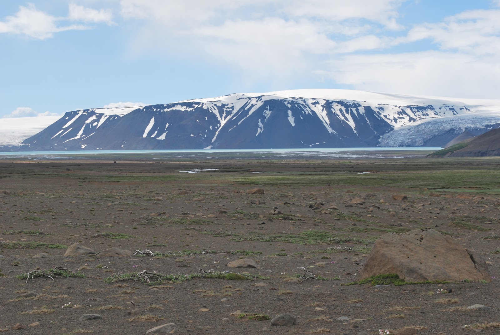
Along the F35, barren land with a glacier in the background.

At the rim of Hverfell Crater.

At the rim of Stora Viti Crater of Mt Krafla.

Red rocks near Hafragilsfoss.

And what does one do when one sees another car on the side of the road with a flat tire?  One stops to help out.  Here Nick and Giuseppe (from Switzerland) who was driving in front of us, stop to help Helga from Akureyri change her flat tire on the F35.

If anyone is wondering about washrooms or WCs along the way, well, not to worry.  We were given a detailed road atlas that described where all the facilities were to be found.  And yes there are plenty along the way, most free, some with a nominal fee like 200 kronur.  They have running water and have toilet paper.

A couple of pictures showing facilities in the middle of nowhere!

I think this one was meant to be a joke.  But it was useable and believe me there are not often cars going by.

This one is literally on the side of the mountain near a campground (near Thorsmork).